Storm Debris Pick Up

We have been advised by Best Trash that they will continue to pick up trash and yard waste all day today. Their first priority was to pick up the smelly trash first since it had accumulated from the holiday and no pickup on Monday. They will then continue to pick up yard waste as per the rules on our website. As long as it is bagged or bundled or in containers, they will pick it up. They told us they will continue to collect even if it takes till 10 p.m. tonight. They have their supervisors out driving trucks and, if a truck from another subdivision is finished, they are sending it to Bentwater to help collect.

Please note Best Trash cannot pick up large branches or loose trimmings unless they are bagged or bundled.

Thank you.
Your MUD Board:
Susan McFarland, President
David Parkhill, Vice President
Gary Montgomery, Treasurer
Rex Cambern, Secretary
John Crystal, Assistant Secretary

Storm Debris Pick Up2024-07-12T12:42:14-05:00

Summer Newsletter

MUD 18 Newsletter
July – September 2024

Holiday Schedule for Best Trash

Please note the holidays for Best Trash: New Years Day, Memorial Day, Independence Day, Labor Day, Thanksgiving Day, and Christmas Day. If Bentwater’s pick-up day falls on one of these holidays, Best Trash will resume service on the next scheduled pick-up day – not the next calendar day.  Also, heavy trash is picked up each trash day as long as the rules are followed.

Also, Best Trash rewards its crews for positive feedback from customers, so if you see an employee doing something extra or worth noting let us know so we can pass it on.  Let’s let our crew know we appreciate their good service.

Drainage Maintenance

Hays Utility has started its annual clean up and repair of the drainage easements maintained by MUD 18 in preparation for hurricane season.  Drainage issues can be confusing as to who is responsible for correcting them.  Sometimes it is the homeowner’s responsibility, sometimes the Country Club, or the POA, or MUD 18.  If you know of any issue, please contact Hays Utility at 936-588-1166 to report it.  They will check it out and get back to you with an answer.

In the same light, if you see a water leak running down the street, a leaky fire hydrant, or a red light on one of the sewer lift stations, let Hays Utility know day or night.  It is up to us to help conserve our water resources.

Website

Please bookmark the MUD website for information about water, sewer or trash questions.  There is a lot of helpful information on the website (https://www.mcmud18.com) with links to other sources.

Suggested Watering Guidelines for Your Property

Proper watering is critical to your lawn’s health and vigor. Deep and infrequent watering is the best practice. This means wetting the soil to a depth of 3-5 inches per irrigation. This equates to 1-1.25 inches of water per week, split over several days.  Your run times should be adjusted based on how dry your yard is. Winter watering should have run times 50% less than your summer run schedule.

Watering is most beneficial to your grass when done in the morning (3 a.m. to 8 a.m.) rather than afternoon or evening.  Avoid overnight watering. Early morning watering allows the leaf blades to dry and reduces the risk of disease.  Do not water every day or two. Frequent, short watering encourages shallow roots, unhealthy grass plants, and turf susceptible to drought and disease.

Let the turf determine watering frequency. Since heat, humidity and rainfall vary, it’s best to water at the first signs of stress, not on a predetermined schedule.  As a note, St. Augustine turf has poor drought tolerance and requires more irrigation to survive during our long hot summers.

Water newer plants 3-4 times per week for no more than 5 minutes.  Keep the ground around new trees and shrubs moist initially using a soaker hose or drip line but gradually back off after two weeks.

Recommended Lawn Watering Schedule

Here are some general lawn-watering guidelines and tips:

Irrigation Spray Head Averages

  • Pop-up spray heads: 10-12 minutes, 3 times per week = 1”
  • Rotary spray heads:  16-23 minutes, 3 times per week = 1”

Suggested Irrigation System Settings

Some irrigation timers have a seasonal adjustment setting that enables you to reduce or increase watering without changing zone settings.  Suggested settings for our area are as follows:

November, December, January and February = 0%
March              50%
April                 70%
May                 80%
June                90%
July/August   100%
September     70%
October           50%

Your MUD Board:

Susan McFarland, President
David Parkhill, Vice President
Gary Montgomery, Treasurer
Rex Cambern, Secretary
John Crystal, Assistant Secretary

Summer Newsletter2024-07-02T22:20:55-05:00

Hurricane Preparedness 2024

National Hurricane Preparedness 2024

Be ready for hurricane season. Today you can determine your personal hurricane risk, find out if you live in a hurricane evacuation zone, and review/update insurance policies. You can also make a list of items to replenish hurricane emergency supplies and start thinking about how you will prepare your home for the coming hurricane season. If you live in hurricane-prone areas, you are encouraged to complete these simple preparations before hurricane season begins on June 1.

Find out today what types of wind and water hazards could happen where you live. Hurricanes are not just a coastal problem. Impacts from wind and water can be felt hundreds of miles inland, and significant impacts can occur regardless of the storm’s strength. Know if you live in an area prone to flooding, if you live in an evacuation zone, and identify any structural weaknesses in your home.

Consider Your Threats
While hurricanes pose the greatest threat to life and property, tropical storms and tropical depressions also can be devastating. The primary hazards from tropical cyclones (which include tropical depressions, tropical storms, and hurricanes) are storm surge flooding, inland flooding from heavy rains, destructive winds, tornadoes, and high surf and rip currents.

  • Storm surge is water that is pushed toward the shore by winds swirling around the storm, and historically has caused the largest loss of life in hurricanes. This rise in water level can cause severe flooding in coastal areas, which can submerge entire areas, cause structural damage to buildings, and wash out roads. Storm surge can travel several miles inland, especially along bays, rivers, and estuaries.
  • Flooding from the extreme amounts of rain a hurricane can bring has also proven to be very deadly, both over an extended period of time as well as very short-term flash flooding. Homes and businesses could flood, and flooded roads could make travel and evacuations difficult, as well as being a potentially deadly hazard to those in vehicles or on foot. Floodwaters can also contain harmful bacteria, chemicals, wildlife and other dangerous objects. Extreme rain from hurricanes can even flood areas that aren’t normally prone to flooding. Flooding can happen hundreds of miles inland, and can persist for several days after a storm.
  • Hurricane-force winds can cause damage to homes and other buildings, ranging from moderate to catastrophic depending on both wind speed and structural integrity. Wind damage can lead to large areas with power and communications outages, as well as uproot trees and make roads impassable due to debris. Signs, roofing material, and other items left outside can become flying missiles during hurricanes. Mobile homes are especially vulnerable to wind damage.
  • Hurricanes and tropical storms can also produce tornadoes. These tornadoes most often occur in thunderstorms embedded in rain bands well away from the center of the hurricane; however, they can also occur near the eyewall.
  • Waves from distant storms can produce deadly rip currents and rough surf on beaches very far away. Good weather at the beach itself does NOT mean the ocean is safe. Even storms more than 1,000 miles away can cause impacts.

Determine if you live in a flood-prone area
Anyone living in a flood-prone area is especially vulnerable to hurricane impacts. Find out today the flood risk for your area and plan accordingly. If you don’t live in a flood zone, that doesn’t necessarily mean you’re safe – extreme rain from hurricanes can bring floods even to areas that aren’t prone to flooding.

Find out if you live in an evacuation zone
Determine if you live in a storm surge evacuation zone. This can tell you about your vulnerability to storm surge, and will be imperative when it comes time to develop an evacuation plan.

Identify your home’s structural risks
Find out if your home has any weaknesses that could prove deadly in a hurricane. Are your exterior doors and garage door hurricane proof? Do you have storm shutters? Some aspects of your home can be strengthened to help withstand hurricane impacts, and some can not. Mobile homes are especially vulnerable to hurricane-force winds, and basements are especially vulnerable to storm surge and flooding.

Additional Resources:

The best time to prepare is before hurricane season begins. Avoid having to rush through potentially life-saving preparations by waiting until it’s too late. Get your disaster supplies while the shelves are still stocked, and get that insurance checkup early, as flood insurance requires a 30-day waiting period.

Develop an evacuation plan
If you are at risk from hurricane impacts, you need an evacuation plan. Now is the time to begin planning where you would go and how you would get there. You do not need to travel hundreds of miles. Your destination could be a friend or relative who lives in a well built home outside flood prone areas. Plan several routes. Be sure to account for your pets.

If you don’t have a vehicle, check with local officials to see what transportation options they may have available.

Assemble disaster supplies
Whether you’re evacuating or sheltering-in-place, you’re going to need supplies not just to get through the storm but for the potentially lengthy and unpleasant aftermath. Have enough non-perishable food, water and medicine to last each person in your family a minimum of 3 days (store a longer than 3-day supply of water, if possible). Electricity and water could be out for weeks. You’ll need extra cash, a battery-powered radio and flashlights. You may need a portable crank or solar-powered USB charger for your cell phones. And lastly, don’t forget your pets!

Get an insurance checkup & document your possessions
Call your insurance company or agent and ask for an insurance check-up to make sure you have enough insurance to repair or even replace your home and/or belongings. Remember, home and renters insurance doesn’t cover flooding, so you’ll need a separate policy for it. Flood insurance is available through your company, agent, or the National Flood Insurance Program at floodsmart.gov. Act now, as flood insurance requires a 30-day waiting period.

Take the time before hurricane season begins to document your possessions: photos, serial numbers, or anything else that you may need to provide your insurance company when filing a claim.

Create a communication plan
Take the time now to write down your hurricane plan, and share it with your family. Determine family meeting places, and make sure to include an out-of-town location in case of evacuation. Write down on paper a list of emergency contacts, and make sure to include utilities and other critical services — remember, the internet may not be accessible during or after a storm.

Strengthen Your Home
Now is the time to improve your home’s ability to withstand hurricane impacts. Trim trees. Install storm shutters, accordion shutters, and/or impact glass. Seal outside wall openings. Remember, the garage door is the most vulnerable part of the home, so it must be able to withstand hurricane-force winds. Many retrofits are not as costly or time consuming as you may think. If you’re a renter, work with your landlord now to prepare for a storm.

And remember – now is the time to purchase the proper plywood, steel or aluminum panels to have on hand if you need to board up the windows and doors ahead of an approaching storm.

  • National Weather Service forecast products can tell you a lot about what is expected to happen with a storm, including the storm’s paths, rainfall amounts, wind speeds, and more. There is a lot of information available days ahead of a storm, and it is important to understand what it means.Have trusted sources for storm information
    Rely on official forecasts and well-established media partners in the Weather Enterprise. Be cautious of sensational headlines and instead look for reliable sources to determine a storm’s potential impacts.
    Use the official National Hurricane Center Forecast — their hurricane specialists access a variety of data (models, aircraft, satellite) to make the most accurate forecasts possible. Meteorologists at local NWS offices understand which locations in your area are most vulnerable to storm surge, flooding, and wind.
    Always check to make sure you have the latest forecast information.
    Make sure to have Wireless Emergency Alerts enabled on your phone to receive Warnings.Know your alerts & the difference between a Watch & Warning
    In general, a Watch means impacts are possible; a Warning means impacts are expected or happening. Different hazards and alerts require different responses:

    • Hurricane Watch means hurricane conditions are possible somewhere within the watch area, with tropical-storm-force winds beginning within the next 48 hours. Prepare by boarding up windows and moving loose items indoors, and make sure your emergency kit is ready. A Hurricane Warning means hurricane conditions  are expected somewhere within the warning area, with tropical-storm-force winds beginning within 36 hours. Seek shelter in a sturdy structure or evacuate if ordered.
    • Tropical Storm Watch means tropical storm conditions are possible within the next 48 hours, a Tropical Storm Warning means they are expected somewhere within the warning area. Remember, a tropical system does not have to reach hurricane strength to be deadly.
    • Storm Surge Watch means the possibility of life-threatening inundation generally within 48 hours, and a Storm Surge Warning means the danger of life-threatening inundation generally within 36 hours. In either case, please promptly follow evacuation and other instructions from local officials.
    • An Extreme Wind Warning means extreme hurricane winds (115 mph+) are imminent or happening: take immediate shelter in an interior portion of a well-built structure.
    • Flash Flood Warning means dangerous flash flooding is expected: move to higher ground, and never walk or drive through floodwater. A Flash Flood Emergency is issued for exceedingly rare situations when a severe threat to human life and catastrophic damage is happening or about to happen — do NOT attempt to travel unless you are under an evacuation order or your life is imminently at risk.
    • Flood Watch means flooding is possible: stay tuned to trusted news sources and be ready to seek higher ground. A Flood Warning means flooding is happening or about to happen: move to higher ground immediately.
    • Tornado Watch means a tornado is possible: know your safe place and be ready to act quickly if a Warning is issued. A Tornado Warning means a tornado is happening or about to happen – immediately seek shelter in your safe place!

    Focus on potential impacts regardless of storm size or category
    Do not focus on a specific storm category; all hurricanes and tropical storms can bring life-threatening storm surge, inland flooding, and damaging winds. The storm’s scale only tells you about the strongest winds near the center of the storm and does not tell you about potentially life-threatening flooding from storm surge or rain. Remain vigilant even if the winds  have weakened  and the storm becomes a  lower category or tropical storm — rainfall and storm surge impacts often continue.

    Deadly hazards occur well outside of the cone
    Impacts can be felt far from the storm’s center, even well inland and outside the Forecast Cone. Remember: the storm itself can stretch well beyond the Forecast Cone, and so can the impacts.

    The National Hurricane Center Forecast Cone shows the probable forecast track of the center of the storm. This means that the storm’s center will probably travel somewhere within the cone’s boundaries. (Historically, the storm’s center has remained within the forecasted cone roughly two-thirds of the time.) The cone does NOT represent the size of the storm in any way.

  • When a storm is forecast to impact your area, take action immediately to be ready. Ideally, longer-term preparedness actions such as having disaster supplies and an evacuation plan will have already been done before hurricane season, when the stores are stocked and time is on your side. When a storm threatens, there’s a lot more to do.Protect your home
    While longer-term home improvement needs to be done well ahead of time, when a storm threatens there are short-term actions to help protect your property. Board up windows, secure loose outdoor items, and secure all exterior doors. Move your vehicle to a safe location if you’re not using it to evacuate. If you are evacuating, unplug electrical equipment such as radios, televisions and small appliances (freezers and refrigerators also need to be unplugged if there is a risk of flooding). If you are instructed to do so, shut off water, gas and electricity before leaving.

    Determine sheltering options & consider your pets
    Check with local officials to find out what shelter spaces are available. If you have pets, find a place where they can stay — most public shelters only allow service animals. In general, have multiple sheltering options, including distant ones such as a friend’s home outside of the impact area, or a motel. Depending on the circumstances, your home may need to be your shelter — make sure it is prepared and that you know the safest places inside.

    Ready your go-bag, meds & supplies, charge phone, fill up/charge vehicle
    Have a go bag ready to take things with you if you need to leave in a hurry. In addition to basic survival needs, don’t forget other supplies such as chargers and hygiene products. Plan to have enough for at least three days, and don’t forget about your pets. While preparing these basic needs, don’t forget to keep your phone charged, and make sure to fill up/charge your vehicle as well.
    Your go-bag should also contain important personal and property documents, including your written communication plan.

    Help your neighbors, especially the elderly & other vulnerable people
    Many people rely on their neighbors before and after a disaster, and there are many ways you can help them. Help them prepare for a storm, and help them evacuate if needed. Share the latest forecast information with your community so that they know what to expect.

    Follow evacuation orders if given
    Always follow evacuation orders from local authorities — don’t wait for a hurricane to intensify before deciding to follow the order. You want to leave early enough to avoid being trapped by severe weather. If time allows, unplug electrical equipment, leave a note detailing your whereabouts, and check to see if any neighbors need a ride.

During a storm, whether you’ve evacuated or are sheltering in place, know what to expect from the hazards you may face. Remain vigilant, stay up-to-date with the latest forecasts and alerts, and continue to listen to local officials.

Stay in your safe places from water & wind
Always keep a safe distance from flooded and damaged areas. When you’re at risk from storm surge or flooding, it’s important to get to high ground away from bodies of water and any flood-prone areas. Evacuate if told to do so. Never drive through floodwaters or compromised bridges. Always pay attention to barriers and signage.

If your house becomes flooded and you’re still there, get higher in your house to escape the flood waters. If the highest floor of your home becomes dangerous, get on the roof and call 911.

Though rain and storm surge cause more direct deaths, wind can also be very destructive and deadly in hurricanes. Winds can be stronger higher above ground level. This can put high-rise buildings at a greater risk. To protect yourself from wind, the best thing you can do is put as many walls as possible between you and the outside. An interior room without windows is the safest place you can be in a building. You can cover yourself with a mattress and wear a helmet for added protection. If your area is under an Extreme Wind Warning, take shelter immediately. Make sure to stay sheltered until the threat is gone.

Have a way to get weather alerts and forecast updates
Make sure to have Wireless Emergency Alerts enabled on your phone to receive Warnings and other alerts. Always pay attention to the latest forecast as conditions can change quickly and storms can rapidly intensify from a tropical storm to a major hurricane. Even small changes in the storm’s track can make a big difference.

Keep in mind that impacts can be felt far from the coast
Remain vigilant even if you’re far from the most damaging winds. Inland flooding can be felt hundreds of miles from the coast. Never drive through floodwaters! A car can be swept away with only a foot of water, and there’s no way to know if the road itself has collapsed when hidden by water.

Listen to local officials & avoid travel unless ordered to evacuate
Local officials can provide you with up-to-date information as the situation changes in your area. Evacuation orders may still be given at this late stage — leave immediately if ordered! Follow recommended evacuation routes — do not take shortcuts, as they may be blocked. Be alert for road hazards such as washed-out roads or bridges and downed power lines. Never drive through floodwaters.

Dangers remain even after the skies turn blue. This is NOT the time to put your guard down. Nearly half of hurricane fatalities occur after the storm.

If you evacuated, only return home only when told to do so
Return home ONLY when officials say it is safe. ​​Check with local officials both where you’re staying and back home before you travel.

Remain vigilant, as hazards remain

  • Be careful near damaged buildings. Walk carefully around the outside of your home to check for loose power lines, gas leaks, and structural damage, including dangerous debris such as nails or glass. Leave your home if there’s shifting or unusual noises. If you smell gas, get outdoors immediately and call 911.
  • Avoid electric shock by staying far away from downed power lines. Stay alert: they may be on the ground, hidden in water, or dangling overhead.
  • Flooded roads are very dangerous. It can be difficult to judge how deep or swift the water is moving — just 12 inches of water can float a car. Never drive through flooded roads, even if you are seeking supplies or trying to check on someone. Floods can also compromise bridges and roads. Avoid flooded river areas, as they can continue to rise long after a storm passes.
    Don’t walk in floodwaters, either — they can contain harmful bacteria, chemicals, sharp objects, and dangerous animals.

Clean up safely: don’t push yourself, and check on neighbors
Stay hydrated, wear light, loose-fitting clothing, and clean up during cooler hours if possible. Don’t push yourself: straining the body can lead to heart attacks, heat strokes, and other serious issues. Perform cleanups slowly, taking lots of breaks. Make sure to check on your elderly neighbors and other vulnerable people in your community. If your area is under a Heat Advisory, use extreme caution and consider cleaning up when the heat has subsided.

Practice portable generator safety
Be very careful with portable generators: carbon monoxide poisoning is one of the leading causes of death in areas dealing with power outages. Never use a generator inside your home or garage, even if doors and windows are open. Only use generators outside, more than 20 feet away from your home, doors, and windows.

Help and communications may not be readily available
After a hurricane, emergency responders may be overwhelmed. Be aware that it could take hours or days for them to reach your area. Communication systems may be impacted, and making phone or video calls might be difficult due to network congestion. If possible, communicate via text, email, or social media.

Are you ready for hurricane season? Take action TODAY to be better prepared for when the worst happens. Understand your risk from hurricanes, and begin pre-season preparations now. Make sure you understand how to interpret forecasts and alerts, and know what to do beforeduring, and after a storm. Even if you are already well-prepared and knowledgeable, there may be additional things you could do or learn to be even more prepared.

Hurricane Preparedness 20242024-05-06T18:09:47-05:00

Best Trash will NOT Empty Other Company’s Containers

Best Trash will not empty other company’s containers, please do not use Waste Management’s 96-gallon bins. If you want to get rid of them Best Trash will pick up the empty Waste Management containers on Monday February 12,2024. You can also take them to the Waste Management collection center in Conroe. As far as Waste Management is concerned the containers are yours to keep.

Your MUD board
Susan McFarland, President
David Parkhill, Vice President
Gary Montgomery, Treasurer
Rex Cambern, Secretary
John Crystal, Assistant Secretary

Best Trash will NOT Empty Other Company’s Containers2024-02-12T10:18:00-06:00

Important Notice: Change to Garbage and Recycling Services

Please be aware that changes are coming to your garbage and recycling services. The Montgomery County MUD 18 contract with Waste Management of Texas expires on December 31, 2023. Because Waste Management is changing to semi-automated pick-ups, which would mandate using wheeled bins like the 96-gallon recycling containers, the MUD board felt the new contract would not benefit Bentwater residents. Therefore, we accepted a new contract with Best Trash to provide all of Bentwater’s residential solid waste services, including collection of household garbage, bulk waste, yard waste, and recycling.

With Christmas and New Years falling on Mondays this year, Waste Management’s final pick up will be on Thursday December 28,2023 for trash and recycling. Best Trash’s first pick up will be on Thursday January 4, 2024 for trash and bulk items only. To better serve our residents, Best Trash will pick up garbage and bulk items on Mondays and Thursdays, and recycling will be picked up on Mondays.

Best Trash will provide each household with two 65-gallon containers, one for garbage and one for recycling. Yard waste can be placed in the garbage container or bagged and placed next to it. The same guidelines for garbage and recycling that applied to Waste Management will apply to Best Trash as to what is acceptable for pick up.
Once it is available, we will provide the schedule for delivery of the new containers to each home. There is no charge for these new containers. Since we are approaching the holidays, if you plan on being out of town, please arrange with a neighbor to move the new containers away from the curb. As of this time, we have not heard from Waste Management when they plan to collect the 96-gallon recycling containers. The existing garbage container is yours to keep.

Your MUD Board:
Susan McFarland, President
Lou Tichacek, Vice President
Gary Montgomery, Treasurer
Rex Cambern, Secretary
John Crystal, Assistant Secretary

Important Notice: Change to Garbage and Recycling Services2023-12-13T17:34:27-06:00

Fall Newsletter- 2023

MUD 18 Newsletter
October – December 2023

2023 Tax Rate

The new tax for 2023 will be $0.232 per $100 of valuation. This is a $0.028 ( 10.8 % ) drop from the previous year. On average, the home valuation in the district increased about $60,882, and the Board wants to maintain the revenue as close as possible to last year. Last year the average tax bill was $1,454, while this year it will be $1,439. Please note that this is an average, meaning some bills will be higher and some bills will be lower. Everything will be based on your property’s assessed value and if you had a successful protest outcome. It is the intention of the Board to collect only what is needed to meet our debt obligations and our planned capital expenditures in the five-year plan to maintain the plants and equipment.

Suggested Watering Guidelines for Your Property

Proper watering is critical to your lawn’s health and vigor. Deep and infrequent watering is the best practice. This means wetting the soil to a depth of 3-5 inches per irrigation. This equates to 1-1.25 inches of water per week, split over several days. Your run times should be adjusted based on how dry your yard is. Winter watering should have run times 50% less than your summer run schedule.

Watering is most beneficial to your grass when done in the morning (3 a.m. to 8 a.m.) rather than afternoon or evening. Avoid overnight watering. Early morning watering allows the leaf blades to dry and reduces the risk of disease. Do not water every day or two. Frequent, short watering encourages shallow roots, unhealthy grass plants, and turf susceptible to drought and disease.

Let the turf determine watering frequency. Since heat, humidity and rainfall vary, it’s best to water at the first signs of stress, not on a predetermined schedule. As a note, St. Augustine turf has poor drought tolerance and requires more irrigation than other grasses to survive during our long hot summers.

The soil around new shrubs needs to be kept moist but not soggy. Water them 3-4 times per week for no more than 5 minutes each time. Keep the ground around new trees moist initially by using a soaker hose or drip line, but gradually back off after 2 weeks.

Tips to Prevent a Leaking Water Heater Disaster

Fortunately, most water heater problems can be avoided with proper maintenance. If you follow these steps once or twice a year your water heater should last a long time, work efficiently, and avoid a leaking disaster.

1. Check Temperature & Pressure-Relief Valve

Test the temperature and pressure-relief valve (T&P valve) once a year to make sure it’s working properly. Use caution: The water in the tank is hot and can cause scalding burns. When you pull up or push down on the valve handle, hot water should come out of the overflow pipe. If it does not, it may need replacing. You can do this yourself but a better option is to call a professional plumber.

2. Drain Water

Periodically, about every 12-16 months, drain a bucket of water from the drain faucet at the bottom of the water tank to remove sediment. The sediment can corrode the unit and reduce heating efficiency.

3. Check Water Lines

Check all of the water lines, fittings and valves connected to your water heater. Look for signs of leaking water. Using a flashlight, check under the tank for small leaks that could be caused by rust or corrosion.

4. Use a Drain Pan

Use a specially designed drain pan (also called a drip pan) under the water heater. They come in all sizes and are circular or square. You can find a decent drain pan for $15-30 at your local hardware or building supply store. Make sure it has a drain at the bottom, and periodically check to make sure it is not clogged.

5. Check the Sacrificial Anode

Water is known for causing rust, corrosion and general harm to metals. So, have you ever wondered what prevents water from damaging the metal of your water heater tank? This protection is often provided by a sacrificial anode rod installed in your unit.

REMINDER

For any water, sewer or other issues concerning MUD 18, please contact our operator Hays Utilities North at 936-588-1166. Hays personnel are usually in Bentwater during the day to respond to emergencies. Also refer to our web site https://www.mcmud18.com to look for answers to other questions.

Your MUD Board:
Susan McFarland, President
Lou Tichacek, Vice President
Gary Montgomery, Treasurer
Rex Cambern, Secretary
John Crystal, Assistant Secretary

Fall Newsletter- 20232023-10-04T19:08:30-05:00

Spring Newsletter- 2023

MUD 18 Newsletter
April – June 2023

Construction on FM 1097

The construction on the South side of FM 1097 for a 12-inch water main from Water Plant 2 to Pine Branch Drive is almost finished.  This project will loop Bentwater’s entire water district to provide redundancy and better maintain constant water pressure.  If for some reason there is an issue at one of our water plants, the other plant will be able to maintain the district’s water supply without any noticeable effect. The final stages of testing and flushing will be completed by the first week of April (weather permitting).

Suggested Watering Guidelines for Your Property

With high heat and drought conditions expected to impact usage, it is important to conserve water.  Since each property has different landscaping layouts and sizes, please review the following water guidelines and make adjustments to suit your particular conditions.

Deep and infrequent watering is the best your lawn’s health and vigor. This means wetting the soil to a depth of 3-5 inches per irrigation. This equates to 1-1.25 inches of water per week, split over several days.  Run times should be adjusted based on how dry your soil is. Winter watering should have run times 50% less than your summer run schedule.

Watering is most beneficial to your grass when done in the morning (3 a.m. – 8 a.m.) rather than afternoon or evening.  Avoid overnight watering. Early morning watering allows the leaf blades to dry and reduces the risk of disease.  Do not water every day or two. Frequent, short watering encourages shallow roots, unhealthy grass plants, and turf susceptible to drought and disease.

Let the turf determine watering frequency. Since heat, humidity and rainfall vary, it’s best to water at the first signs of stress, not on a predetermined schedule.  As a note, St. Augustine turf has poor drought tolerance and requires more irrigation than other grasses to survive our hot weather months.

Water newer plants 3-4 times per week for no more than 5 minutes.  Keep the ground around new trees and shrubs moist initially using a soaker hose or drip line but gradually back off after two weeks.

Recommended Lawn Watering Schedule

Here are some general lawn-watering guidelines and tips:

Irrigation Spray Head Averages
Pop-up spray head: 10-12 minutes, 3 times per week = 1”
Rotary spray heads: 16-23 minutes, 3 times per week = 1”

Seasonal Watering Recommendations
January & February – Rainfall is usually adequate. Water if no rainfall for four weeks.
March, April & May – Water only once per week if less than one inch of rainfall occurs.
June, July, August & Early September – Water each section heavily at least twice a week if less than one inch rainfall.
Late September & October – REDUCE WATER FREQUENCY!
Early fall is Brown Patch Season, and excess water triggers this disease. During September water only once per week if no rainfall and every two weeks in October if no rain.
November & December – Rainfall is usually adequate. Water if no rainfall for four weeks

Suggested Irrigation System Settings

Some irrigation timers have a seasonal adjustment setting that enables you to reduce or increase watering without changing zone settings.  Suggested settings for our area:

November, December, January and February 0%
March 50%
April 70%
May 80%
June 90%
July/August 100%
September 70%
October 50%

Just so you know…

In 2022 the district pumped 497,861,000 gallons of water, and 120,627,000 gallons went through the waste treatment plant.  This means on average 75.77% of our water (377,234,000 gallons was used for irrigation, car washing, pressure washing, filling swimming pools, drinking or leaks.  During the warmer months the percentage is over 80%, which means irrigation is our largest user of water.  Please conserve water whenever possible.

If you have questions about MUD 18 go to our website at https://www.mcmud18.com for answers about water, sewer or trash pickup.

Your MUD Board:

Susan McFarland, President
Lou Tichacek, Vice President
Gary Montgomery, Treasurer
Rex Cambern, Secretary
John Crystal, Assistant Secretary

Spring Newsletter- 20232023-04-04T21:28:14-05:00

Winter Newsletter

MUD 18 Newsletter
January – March 2023

Sign up for Alert Notifications

When you go to the MUD 18 website home page, a pop-up will appear asking you to sign up for emergency alerts. You can sign up for email alerts, text alerts, or both. At a minimum, we urge all customers to sign up for text alerts. We want to make sure all our customers can be notified in case of emergency. This system will be used only in emergency situations where the community needs to be notified for health or safety reasons. Also, please bookmark our website (http://www.mcmud18.com) as most questions about water, sewer, and trash pickup are answered there. If your water and sewer questions are not answered on our web site, contact our operator Hays Utility North at 936-588-1166. For trash and recycle information, contact Waste Management at 800-800-5804. Please remember the customer for Waste Management is M.U.D. 18, not Bentwater.

Recycling

Over the years Bentwater residents have done a great job of recycling, thereby reducing the amount of solid waste sent to the landfill. Each year the amount we recycle keeps going up. Waste Management furnished each homeowner a 96-gallon cart, with a YELLOW lid, for recycle items. Please only use this container for recycling. Home owners must supply their own container for trash pickup. Remember, only items placed in the bin with the yellow lid will be picked up for recycling as there is only the driver and the pickup is automated. If recyclables are placed next to the bin they will not be picked up. Cardboard boxes should be collapsed to fit in the bin. Even better, cut them up into smaller pieces, which will enable you to get more in the bin.

Always recycle: plastic bottles and containers, food and beverage cans, paper, cardboard and paper board, glass bottles and containers. Place only clean and dry recyclables in your recycling cart.

Do not recycle: food or liquids; Styrofoam cups or containers; loose plastic bags such as those from the grocery store or dry cleaners; film of any kind; bagged recyclables; batteries or electronics; green waste; clothing; furniture or carpeting; rope or wire; shredded paper. Since Waste Management is a single stream recycler (we do not have to separate items) it is important not to put anything in the recycler that will get caught in the spinning discs at the plant. If the discs get tangled with wire rope or plastic bags the system has to be shut down and cleaned out. Therefore, even wire hangers from the dry cleaners cannot be recycled.

Regular Trash Collection: Monday and Thursday

Please be sure your trash is at the curb by 7:00 a.m. on collection day.
Household garbage, grass clippings, leaves, branches and tree trimmings are collected at the curb. You are limited to 10 bags, bundles or containers per collection. Containers over 45 gallons must have all trash bagged.

Bulky Trash Collection: Thursday

Limit: Two bulk items
Acceptable items include moving boxes (please break them down and bundle them), old furniture, appliances, grass clippings, leaves, branches and tree trimmings.
Important: For the safety and protection of Waste Management employees and equipment, branches and tree trimmings need to be no greater than 3 inches in diameter and to be cut, tied and bundled into 4-foot lengths weighing no more than 40-50 pounds.

Please note! Waste Management can no longer dispose of CFC refrigerant containing items (refrigerators, freezers, etc.) without certification that the Freon has been properly removed and recycled, pursuant to current Federal law.

Unacceptable Items:
Gasoline & oil (cans/filters); vehicle tires; large pieces of metal; landscape materials; rocks; electronic waste (such as televisions/computers, monitors); construction debris (paint & carpet, etc.); glass (i.e. windows, bathroom mirrors resulting from construction projects); propane tanks.

MUD Meetings Open to the Public

Our regularly scheduled monthly meetings are the third Tuesday of the month at 9:30 a.m. in the Country Club Cypress Room. Meetings are open to the public. The agenda is posted on our web site and the message board in the breezeway entrance to the Country Club Grill near the Golf Pro-shop. Minutes from meetings are published on the MUD 18 web site.

Your MUD Board:
Susan McFarland, President
Lou Tichacek, Vice President
Gary Montgomery, Treasurer
Rex Cambern, Secretary
John Crystal, Assistant Secretary

Winter Newsletter2023-01-05T17:56:11-06:00

Fall Newsletter

MUD 18 Newsletter
October – December 2022

2022 Tax Rate
The new tax for 2022 will be $0.26 per $100 of valuation.  This is a $0.03 drop from the previous year.  On average, the home valuation in the district increased about $50,000, and the Board wants to maintain the revenue as close as possible to last year.  Last year the average tax bill was $1,452, while this year it will be $1,454.  Please note that this is an average, meaning some bills will be higher and some bills will be lower than the average.  Everything will be based on your property’s assed value and if you had a successful protest outcome.  It is the intention of the Board to collect only what is needed to meet our debt obligations and our planned capital expenditures in the five year plan to maintain the Districts plant and equipment.

Construction on FM 1097
Starting October 3, 2022, you will begin to see construction on the South side of FM 1097 for a 12-inch water main from Water Plant 2 to the East entrance of Bentwater.  This project will loop Bentwater’s entire water district to provide redundancy and better maintain constant water pressure.  If for some reason there is an issue at one of our water plants the other plant will be able to maintain the district without any noticeable effect.

Suggested Watering Guidelines for Your Property
Proper watering is critical to your lawn’s health and vigor. Deep and infrequent watering is the best practice. This means wetting the soil to a depth of 3-5 inches per irrigation. This equates to 1-1.25 inches of water per week, split over several days.  Your run times should be adjusted based on how dry your yard is. Winter watering should have run times 50% less than your summer run schedule.

Watering is most beneficial to your grass when done in the morning (3 a.m. to 8 a.m.) rather than afternoon or evening.  Avoid overnight watering. Early morning watering allows the leaf blades to dry and reduces the risk of disease.  Do not water every day or two. Frequent, short watering encourages shallow roots, unhealthy grass plants, and turf susceptible to drought and disease.

Let the turf determine watering frequency. Since heat, humidity and rainfall vary, it’s best to water at the first signs of stress, not on a predetermined schedule.  As a note, St. Augustine turf has poor drought tolerance and requires more irrigation to survive during our long hot summers.

Water newer plants 3-4 times per week for no more than 5 minutes.  Keep the ground around new trees and shrubs moist initially using a soaker hose or drip line but gradually back off after two weeks.

Recommended Lawn Watering Schedule
Here are some general lawn-watering guidelines and tips:

Irrigation Spray Head Averages
Pop-up spray head: 10-12 minutes, 3 times per week = 1”
Rotary spray heads: 16-23 minutes, 3 times per week = 1”

Seasonal Watering Recommendations
January & February – Rainfall is usually adequate.
Water if no rainfall for four weeks.
March, April & May – Water only once per week if less than one inch of rainfall occurs.
June, July, August & Early September – Water each section heavily at least twice a week if less than one inch rainfall.

Late September & October – REDUCE WATER FREQUENCY!
Early fall is Brown Patch Season, and excess water triggers this disease. During September water only once per week if no rainfall and every two weeks in October if no rain.
November & December – Rainfall is usually adequate. Water if no rainfall for four weeks

Suggested Irrigation System Settings
Some irrigation timers have a seasonal adjustment setting that enables you to reduce or increase watering without changing zone settings.  Suggested settings for our area:

November, December, January and February = 0%
March              50%
April                 70%
May                  80%
June                  90%
July/August     100%
September        70%
October            50%

Your MUD Board:

Susan McFarland, President
Lou Tichacek, Vice President
Gary Montgomery, Treasurer
Rex Cambern, Secretary
John Crystal, Assistant Secretary

Fall Newsletter2022-10-05T12:56:38-05:00

Summer Newsletter

MUD 18 Newsletter
July – September 2022

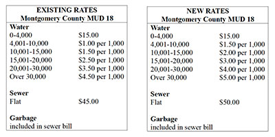
Rate Increase

It has been 12 years since the last water rate change, and operating costs have risen significantly since then. To determine how much your Montgomery County MUD 18 District should be charging for water and sewer services, we asked Bleyl Engineering to review the existing rates in relation to operating and maintenance expenses.  Hays Utility North (which operates our water and sewer plants) provided billing and expense data for water and sewer usage and miscellaneous fees from March 2021 to February 2022.  District Data Services (which handles bookkeeping services for our MUD district) provided annual operating and maintenance (O&M) expenses for the same period as the utility billing.  After analysis, Bleyl informed us that the District’s O&M expenses exceeded its billing revenue by a total of $190,395 during the study period.  A new rate order was determined and applied to the test period, which gave the District a $555 surplus instead of a deficit.  In order to preserve our financial stability and keep the District on a sound financial footing, the board has decided to adjust the water rates accordingly.

The proposed new rate order, which will go into effect in August 2022, is as follows:

  Gallons                                  Rate       

0 to 4,000                                $15.00                         (+$5.00)
4,000 to 10,000                       $1.00 per 1,000 gal.  (no change)
10,001 to 15,000                     $1.50 per 1,000 gal.  (no change)
15,001 to 20,000                     $2.50 per 1,000 gal.  (+$0.50)
20,001 to 30,000                     $3.50 per 1,000 gal.  (+$0.50)
30,001 and over                      $4.50 per 1,000 gal.  (+$0.75)

With high heat and drought conditions continuing to impact usage, it is important to conserve water.  Since each property has different landscaping layouts and sizes, please review the following water guidelines and make adjustments to suit your particular conditions. A useful link for water conservation: https://www.infinityservicesllc.com/latest-articles/water-conservation-2022/

Suggested Watering Guidelines for Your Property

Proper watering is critical to your lawn’s health and vigor. Deep and infrequent watering is the best practice. This means wetting the soil to a depth of 3-5 inches per irrigation. This equates to 1-1.25 inches of water per week, split over several days.  Your run times should be adjusted based on how dry your yard is. Winter watering should have run times 50% less than your summer run schedule.

Watering is most beneficial to your grass when done in the morning (3 a.m. to 8 a.m.) rather than afternoon or evening.  Avoid overnight watering. Early morning watering allows the leaf blades to dry and reduces the risk of disease.  Do not water every day or two. Frequent, short watering encourages shallow roots, unhealthy grass plants, and turf susceptible to drought and disease.

Let the turf determine watering frequency. Since heat, humidity and rainfall vary, it’s best to water at the first signs of stress, not on a predetermined schedule.  As a note, St. Augustine turf has poor drought tolerance and requires more irrigation to survive during our long hot summers.

Water newer plants 3-4 times per week for no more than 5 minutes.  Keep the ground around new trees and shrubs moist initially using a soaker hose or drip line but gradually back off after two weeks.

Recommended Lawn Watering Schedule

Here are some general lawn-watering guidelines and tips:

Irrigation Spray Head Averages

Pop-up spray head: 10-12 minutes, 3 times per week = 1”
Rotary spray heads: 16-23 minutes, 3 times per week = 1”

Seasonal Watering Recommendations

January & February – Rainfall is usually adequate.
Water if no rainfall for four weeks.
March, April & May – Water only once per week if less than one inch of rainfall occurs.
June, July, August & Early September – Water each section heavily at least twice a week if less than one inch rainfall.
Late September & October – REDUCE WATER FREQUENCY!
Early fall is Brown Patch Season, and excess water triggers this disease. During September water only once per week if no rainfall and every two weeks in October if no rain.
November & December – Rainfall is usually adequate. Water if no rainfall for four weeks

Suggested Irrigation System Settings

Some irrigation timers have a seasonal adjustment setting that enables you to reduce or increase watering without changing zone settings.  Suggested settings for our area:

November, December, January and February = 0%

March              50%
April                 70%
May                  80%
June                  90%
July/August     100%
September        70%
October            50%

Your MUD Board:

Susan McFarland, President
Lou Tichacek, Vice President
Gary Montgomery, Treasurer
Rex Cambern, Secretary
John Crystal, Assistant Secretary

Summer Newsletter2022-07-06T14:13:31-05:00
Go to Top